Sunday, March 28, 2021

වෙරළ සහ වෙරළාශ්‍රිත පුරාවිද්‍යාව

 මෙම කෙටි රචනා මාලාවේ අපේක්ෂාව වෙරළ, වෙරළාශ්‍රිත භු රූපන සහ ඒ හා සම්බන්ධ පුරාවිද්‍යා ක්ෂේත්‍ර පිළිබද කෙටි සටහන් කිහිපයක් සකස් කිරීමයි.


හැදින්වීම

වෙරළ යනු අතිශය මනස්කාන්ත සහ ස්වභාවික සම්පත්වලින් අනූන කලාපයකි. ලෝකයේ ජනගහණයනේ සැලකිය යුතු ප්‍රමාණයක් වෙරළබඩ ජීවත්වන අතර ලොව මුල්ම නාගරික සමාජ ද වෙරළබඩ අර්ධශුෂ්ක ගංමුවදොර තැනිතලා ආශ්‍රි්තව බිහිවිය. ප්‍රවාහනය සහ සංචාරක කර්මාන්තය අතින් ද වෙරළට හිමිවන්නේ විශේෂිත ස්ථානයකි. 

මුහුදත් ගොඩබිමත් එකට හමුවන ස්ථානය වෙරළ ලෙස සරලව හැදින්විය හැකිය. නමුත් වෙරළ ආශ්‍රිතව සිදුවන භූ රූප විද්‍යාත්මක වෙනස්කම් අතිශය සංකීර්ණ වන අතර එය හැදෑරීම කුතුහලය දනවයි. භෙෳතිකමය ලෙසින් ජලගතික සහ වායුගතික ක්‍රියාවලීන් ද ශාක සහ සත්ත්ව ජෛවීය ක්‍රියාවලීන් ද මෙම වෙනස්කම් කෙරෙහි බලපානු ලබයි. 

වෙරළ කලාපය

වෙරළ කලාපය මුහුද සහ ගොඩබිම අතර ඇති අතුුුරු මුහුණතකි. සැබැවින් ම වෙරළ යනු මායිම් රේඛාවයක් බදුවුව ද පුළුල් අර්ථයෙන් ජල රේඛාව තුළ ද එයින් ඉහළ ඇති වැලි කදු, වැටි, දඹ ආදිය ද අයත් වන්නකි. තව ද වෙරළ තීරයේ ක්‍රියාවලීන්ගේ බලපෑම සාමුද්‍රික පරිසරවලට මෙන් ම ගොඩබිම වෙත ද බලපෑමක් ඇති කරයි. නෛතික කටයුතු ආදිිය සදහා වෙරළ ඉම පිළිබද අදහසක් පවත්වාගැනීම අවශ්‍ය වුව ද එයට පැහැදිලි සීමාවක් නම් කිරීම අපහසු වේ. 

වෙරළාශ්‍රිත භූ රූපන අධ්‍යනයේදී එහි ඇති භූ ලක්ෂනවල හැඩය, තැන්පතු සහ තැන්පතු වීමේ ක්‍රියාවලීන් දෙස මූලික අවධානයක් යොමු කෙරේ. ගොඩබිම් ක්‍රියාවලීන් මගින් හැඩගස්වනු ලැබූ නොගැඹුරු වෙරළ ද වෙරළ ක්‍රියාකාරීත්වයෙන් හැඩගැස්වූ ගොඩබිම ද හැදෑරීම මෙනිසා අත්‍යවශ්‍ය වේ. මුහුදු මට්ටම්වල උච්ඡාවචනය හේතුවෙන් රට තුළ සකස්වී ඇති භූ ලක්ෂණ ද වෙරළ භූ රූපනවලට ම අයත් වන නිසා වෙරළ සිීමාව අදාල අධ්‍යනය අනුව වෙනස් වනු ඇත. එමෙන් ම රට සිදුවන වෙනස්කම් ද වෙරළ වෙත බලපායි. අස්වාන් වේල්ල නිර්මාණය කිරීම නිසා නයිල් නදියේ ගංමෝයේ තැන්පතවන දියළු ප්‍රමාණය අඩුවූ අතර එයින් වෙරළ ඛාදනය ඉහළ ගොස් ඇත. 


වෙරළාශ්‍රිත භූ රූපන

වෙරළාශ්‍රිත භූ රූපන සකස් වීමට ඒ සදහා පාදක වන ද්‍රව්‍යන්ගේ ස්වරූපය තීරණාත්මක සාධකය වේ. භූ රූපන ලක්ෂණ හැදෑරීම දික් සැලසුමක් හෙවත් වෙරළ තීරයේ සමාන්තරව ඇති ලක්ෂන සැලකීම මගින් හෝ වෙරළ ඡේදනය කරන පැතිකඩ සැලසුමක් මගින් හෝ සිදුකළ හැකි ය. දික් සැලසුමකදී භූ ලක්ෂණ, පාෂාණ ලක්ෂණ, අවසාදිත සහ වෙරළ ඛාදනයට ඇති ප්‍රතිරෝධය දැක්විය හැකි ය. උදම් රළ සීමාව ආදිය ද මෙහිදී දැක්විය හැකි ය. 

වෙරළ පැතිකඩදී භූ රූපන ලක්ෂණ අනුව කලාප බෙදීමට ද එක් එක් කලාපයේ ක්‍රියාවළීන් දැක්වීමට ද පහසු ය. මෙම ක්‍රියාවලීන් හැදින්වීමට එක් එක් විෂයයන්ගේ වෙනස් යෙදුම් භාවිත වනු ඇත. පෑල වෙරළත (backshore) යනු ජල බිදෙන මායිමෙන් ඔබ්බෙහි කලාපයයි. වෙරළාසන්නය (nearshore) යන්නට මුහුදු පතුලේ රළ බිදෙන ඉදිරි වෙරළ කලාපය අයත් වන අතර එයට රළ බිදෙන foreshore සහ onshore යන කලාප අයත් වේ.  ගැඹුරු මුහුද (offshore) ලෙසින් හැදින්වේ. උදම් රළ  බිදෙන ඉම beachface නම් වේ. 

වෙරළාශ්‍රිත අවසාදිත තැන්තපතුවල ස්වරූපය රල සහ දියවැල්වල ක්‍රියාකාරීත්වයෙන් නිතරම වෙනස් වේ. වර්තමාන සහ අතීත වෙනස්කම් අධ්‍යයන කල යුතුවන අතර ඒ සදහා වර්තමානයේ සිදුවන ක්‍රියාවලීන් හැදෑරීම, පැරණි සිතියම් සහ ගුවන් ඡායාරූප හැදෑරීම, ඛාදනය වන ලක්ෂණ සහ තැන්පතු අනුපිළිවෙල උපකල්පනය මේ සදහා උපයෝගී වේ. 

එකිනෙකට වෙනස් ස්ථාන නිරික්ෂණයෙන් වෙරළාශ්‍රිත භූ රූපනවල විවිධකාලවල සිදුවූ වෙනස්කම් අවබෝධ කරගත හැකිය. අවසාදිත තැන්පපතු විදීමෙන් ලබාගන්නා නියැදිවලින් එහි ස්ථරායනය (Stratigraphy) හදුනාගත හැකි අතර සමහර අවස්ථාවලදී එම ස්තරායනය සමගම මතුපිටින් නිරීක්ෂණය කල හැකි යම් භූ ලක්ෂණයක් හැදීරීම (Morphostratigraphy) ද සිදුකල හැකි ය. 

වෙරළ විකාශනය (coastal evolution) හැදෑරීම යනු වෙරළතීරයේ ලක්ෂණ සහ ස්ථානගතවීම් වෙනස් වූ ආකාරයත් වෙනස්වීමට බලපෑ කරුණුත් හැදෑරීමයි. පැරණි වෙරළතීර ප්‍රතිනිර්මාණය කිරීම පුරාවිද්‍යාවට ද අතිශය වැදගත් වේ. මෙය ත්‍රිමානකරණය කිරීමට අවසාදිත ඒකක (sedimentary facies) සහ ජෛව අවශේෂ මගින් පුරාපාරිසරික තත්ත්වයන් ද (paleoecological habitats) හැදෑරීම මගින් කළ හැකි ය.


වෙරළ භූ රූප ගතිකතාවය

coastal morphodynamics 

සමුද්‍රීය සහ දේශගුණික ක්‍රියාවලින් ආදිය නිසා ලෝකයේ වෙරළ තීර නිරන්තරව වෙනස්වන ආකාරය වටහා ගැනීමට වෙරළ භූ රූප ගතිකතාවය හැදෑරීම වැදගත් වේ. මෙය සිදුවන ආකාරය ක්ෂේත්‍ර නිරීක්ෂණ මගින් මෙන් ම විද්‍යාගාරවල ආකෘති ක්‍රියාත්මක කිරීමෙන් ද වටහාගැනීමට උත්සහා කරනු ලබයි. 


කාලය සහ අවකාශය

වෙරළ තීරය පිළිබද හදාරන විට එහි කාලය සහ අවකාශය විවිධ පරාසයන් යටතේ අවධානයට ලක්කළ යුතු වේ. ඉහත ද පැහැදිල කළ ආකාරයට අවකාශය යන්නෙහි ගොඩබිම් සහ මුහුදු සීමාවන් නිර්ණය කිරීම අදාල අවශ්‍යතාවය අනුව තීරණය වන්නකි. දියළු තැන්පතු සමහර අවස්ථාවල ගැඹුරු මුහුදු පතුලේ තැන්පත් වේ. ලවණ ජලයේ බලපෑම ගොඩබිම ශාක වෙත බලපායි. දඹ සහිත වෙරළ තීර කිලෝමීටර සියගණනක් කිසිදු ලාක්ෂනික වෙනසක් රහිතව පැවතිය හැකි අතර වැලි සහිත වෙරළක මීටර කිහිපයක් තුුළ පවා විශාල වෙනස්කම් දැකිය හැකි ය. 

කාලය අනුව ගත්විට භූ විද්‍යාඥයන්ට වසර මිලියන ගණනක ක්‍රියාවලිය වැදගත් වන අතර ඉංජිනේරුවන්ට එක් සෘතුවක වෙරළ වෙනස්වීම් අදාල වේ. පුරාවිද්‍යාඥයන්ට එය මානව සංස්කෘතියේ මුල් වකවානුවල සිට ම සාධක පවතින සහ පැවැතිය හැකි කලාපයකි. චාතුර්ථික සහ එයිනුත් වඩාත් වර්තමාන හොලොසින ක්‍රියාවලීන් මෙනයින් බොහෝ පර්යේෂකයන්ට අදාල වේ. භූූ රූපන හැදෑරිමේදී කාල රාමු තුනක් තුළින් අධ්‍යයනය කළ හැකි බව සැලකේ. 

1. භූ විද්‍යාත්මක කාලය හෙවත් චක්‍රීය කාලය (geological/cyclic time)- දිගු කාලීන වෙනස්කම්

2. අනුක්‍රමික කාලය - Graded time 

3. අඛණ්ඩ කාලය - Steady-state time

නමුත් වඩාත් සංකීර්ණ වූ වෙරළාශ්‍රිත වෙනස්වීම් රටා අධ්‍යයනයට මෙම කාලරාමු ප්‍රමාණවත් නොවන බව 1994 දි කොවෙල් සහ තොම් විසින් යෝජනා කළ අතර ඔවුන්ට අනුව

1. ක්ෂණික වෙනස්වීම් - instantaneous

2. සිද්ධි - event

3. ඓතිහාසික - Historical

4. භු විද්‍යාත්මක - geological

යන කාල රාමු හතර යටතේ එය හැදෑරීම පහසු වේ. රළ බිදෙන ඉමෙහි වැලි තැන්පත්වීම සහ නැවත සේදී යෑම වැනි 'ක්ෂණික වෙනස්වීම්' ක්ෂේත්‍රයේදී අධ්‍යයනය කළ හැකි නමුත් එක් එක් ස්ථානයෙහි මෙම රටා වෙනස් විය හැකිය. එබැවින් වඩාත් සාමාන්‍යකරණය කරන ලද නිගමන ක්ෂණික වෙනස්වීම් සම්බන්ධයෙන් ගොඩනගාගැනීමට සිදුවන අතර දීර්ඝකාලයක් තුළ එවැනි රටා හටගත් ආකාරය හැදෑරීමද අපහසු වේ. සුනාමි, කුණාටු වැනි සංසිද්ධීන් මගින් වෙරළෙහි ඇති කරන වෙනස්කම් 'සිද්ධි' යටතේ හදුනාගත හැකිය. මෙවැනි සිද්ධි ගණනාවක එකතුවකින් අපට 'ඓතිහාසික' වශයෙන් යම් වෙරළක සිදුවූ වෙනස්කම් හදුනාගත හැකිය. වඩාත්තු ම ර්ථික අවධියේ සිදුවූ දීර්ඝකාලීන වෙනස්කම් 'භූ විද්‍යාත්මක' කාලරාමුවට අයත් කළ හැකි ය. මෙම සියල්ල අධ්‍යයනයට ලක්වන අවකාශයේ ප්‍රමාණය අනුව වෙනස්වනු ඇත. 


වෙරළ පද්ධති

Von Bertalanffy විසින් ඉදිරිපත්කරන ලද සාමාන්‍ය පද්ධති න්‍යාය, සංකීර්භ භූ ලක්ෂණ සහ එම ලක්ෂණ සකස් වීමට බලපාන ලද ක්‍රියාවලීන් අතර අන්තර්සම්බන්ධතාවය ගොඩනගාගැනීමට උපයෝගී කරගත හැකිය. ලෝකයේ හදුනාගත හැකි මූලිකාංග (elements) හෙවත් භූථාර්ථ (entities), විචල්‍යයන් (variables) හෙවත් පරාමිතීන් (parameters) හෝ උපලක්ෂණ (attributes) රැසකින් විග්‍රහ කළ හැකි ය. 

පද්ධතියෙන් බාහිරව පවතින සාධක (external factors) ස්වාධීන විචල්‍යයන් ලෙස සැලකේ. බහිර්ජනන (exogenous), බහිර්ජාත (extrinsic or allogenic) යන යෙදුම් ද මේ සදහා භාවිත වේ. මේවා මායිම් භව්‍යත්වයන් (boundary conditions) ලෙසින් ද හැදින්වෙන අතර ඒ ඒවායේ ඇතිවන යම් වෙනසක් පද්ධතිය තුුළ වෙනසක් ඇති කිරීමට පාදක වන බැවිනි. පද්ධතිය තුළ ඇති විචල්‍යයන් පරායත්ත විචල්‍යයන් වන අතර ස්වාධීන විචල්‍යයන්ගේ වෙනස්වීම්වලට අනුකූලව වෙනස් වේ. මායිම් භව්‍යත්වයන්ගේ වෙනසකින් තොරව වුවද පරායත්ත විචල්‍යයන් අතර වෙනස්කම් ඇතිවිය හැකි ය. මෙම අභ්‍යන්තර ගතිකතාවයන් හැදෑරීම වැදගත් වන අතර නොඑසේ නම් යම් වෙනසක් මානව මැදිහත් වීම වැනි බාහිර සාධකයකින් වූයේ බවට වරදවා හදුනාගැනීමේ හැකියාව ද පවතී. නිදසුනක් ලෙස ශ්‍රී ලංකාවේ දකුණු වෙරළ තීරයේ ඇති හොලෝසීන් කවච තැන්පතු අතරින් සමහරක් මානව තැන්පතු ලෙස හදුනාගැනීම දැක්විය හැකි ය. 

පද්ධතියක් ලෙස සලකන්න‌ේ කුමක් ද යන්න අදාල අධ්‍යයනය අනුව වෙනස් වේ. සමස්ථ පෘථිවියම පද්ධතියක් ලෙස ගෙන චාතුර්ථික අවධියේ එහි ග්ලැසියර හා අන්තර් ග්ලැසියර අවධි යන විශේෂිත අවස්ථා දෙක හැදෑරිය හැකි ය. එහිදී පෘථිවියේ භ්‍රමණ - පරිභ්‍රමණ රටාව ස්වායක්ත විචල්‍යයක් වේ. 

එක් පද්ධතියක් තුළ උප පද්ධති ගණනාවක් විය හැකි ය. ගඟ සහ වැලි කඳු එක් පද්ධතියකි. එය පවතින්න‌ේ මුවදොර සහ වෙරළ සහිත පද්ධතියක් තුළය. ජලය ගලා යෑම, ඇළ මාර්ගය සහ මුව දොර ඇති වැලිපරය (shoal) මුවදොරක් ආශ්‍රිත පද්ධතියකි. වෙරළ, රළ බිඳීම, වැලි වැටිය ආදිය වෙරළක පද්ධතියකි. මේ අතර අන්තර්සම්බන්ධතාවයක් වේ. 

අධ්‍යයනයට තෝරාගන්නා අවකාශය අනුව එහි විචල්‍යයන් තීරණය වේ. වැලි පරය හෝ මුවදොර හෝ හුදකලාව ගෙන අධ්‍යයනය කළ හැකි ය. එහිදී ගඟ මගින් ප්‍රවාහනය කරන වැලි ප්‍රමාණය බාහිර විචල්‍යයකි. නමුත් සමස්ථ ගංගා පද්ධතියම හදාරන විට එම වැලි පරිවහනය අභ්‍යන්තර විචල්‍යයක් බවට පත්වේ. එමෙන්ම, පද්ධතියක් විවෘත හා සංවෘත විය හැකි අතර සංවෘත පද්ධතියක ශක්ති හානිය අවම වේ. නමුත් වෙරළ පද්ධතීන් සියල්ල ම අපට විවෘත පද්ධතීන් ලෙස සැලකීමට සිදුවන අතර එහි ජලය, ශක්තිය, අවසාධිත වැනි ඇතුළුවන දෑ සහ පිටවන දෑ ආදිය ආශ්‍රිත ක්‍රියාවලිය ඉතා සංකීර්ණ වේ. 


notes

* The sediments in low sea level during glaciation are termed lowstand system tracts in the terminology of sequence stratigraphy

high sea level sediments are highstand system tracts

* Two distinct morphological states in a wave-dominated beach

   a. Accreted beach

   b. eroded beach


* white-box, grey-box and black box approaches to define the subsystems. 

     - white box - All the components of a sub system are identified

     - black box - no components of sub system are identified 

     - grey box - intermediate of above two


References

Woodroffe, Colin, 2002, Coasts, Cambridge University Press

Thursday, March 11, 2021

Global Geoarchaeology -ARCHON workshop

 By Thilanka Siriwardana, PhD candidate, University of Groningen, the Netherlands

Every problem in archaeology starts with a problem in geoarchaeology…….

Well said Sjoerd!. I have formally started my PhD programme in November 2020 with the University of Groningen. At the very beginning of my field research orienting toward the topic, I'm stuck in nowhere. Holocene beaches, inland Pleistocene palaeo coasts, coastal erosion, new dunes, rapid coastal changes…..! OMG, where now? At the right moment, a three-day workshop on global geoarchaeology: theory and practice gave me many solutions and showed many paths to solve some issues I had.  Thank you Professor Ian Sympson and Professor Sjoerd Kluiving.

A toolbox was nicely presented during three days session, and I tried my best to order it below. 


Knowing the soil family

Current COVID – 19 situation teaching us many lessons and providing many opportunities. Though we missed the physical meetings and interactions as well as get to know each other, the three-day session with the resource persons and participants from several regions of the world proven even the virtual interactions can make a change, and at the end of three days, I felt like in a family.

And so does the soil. Knowing the Sri Lankan soil to some extent but not beyond, Ian and Sjoerd's introduction to the types of soils, their characteristics, archaeological values, and matters to be concerned clarified soil's global commonalities. Soil family! The World reference base for soil resources introduced by the Food and Agriculture Organization of the United Nations (FAO) provides an excellent base to understand these globally. However, why we need to know these?

We recently studied a megalithic burial complex in the Dry zone of Sri Lanka, which has Red-Brown soil and low-humic-gley soil. The land uses slash-and-burn farming, and farmers use individual small land plots to plant different crops such as black gram, corn, finger millet, rainfed paddy, sesame, and other crops, but why? On the other hand, the settlement sites were not visible to the surface, but recent tilling uncovered an artefact deposition ca. 20-30cm below the surface. Identifying these were useful to interpret the anthropological and archaeological data recovered from the study. Geoarchaeology assists us to understand the site and preservation process. Geology and geomorphology hold many secrets. The Anthropogenic diagnostic horizons such as plaggic, terric, hortic, irragic, anthraquic, hydragric and other soil types introduced by Ian will help analyse these.

Identifying the potential soil formations worth to study archaeology is a large issue in Sri Lankan archaeology. Except for the cave deposits, some recent Holocene shell beds, and lithic scatters on the hilltops, most prehistoric and early historical open-air habitation floors are not known widely yet. Sjoerd's hand-drilling and cross-sections study in Egypt was able to provide an insight into these issues.

Meeting CleOPaTRa

Soil forming is a process. Pedogenesis (soil formation) is different from Geogenesis (sedimentation), and soil is forming in the upper part of the earth’s crust, which is a space-time continuum. Soils are different in each place, and there are stimulating factors for the changes. They are,

-          Climate

-          Organisms/Vegetation

-          Parent materials

-          Time

-          Relief/Drainage

The stimulant factors of soil formation have regional variations. In north-western Europe, the climate has the least impact comparing to the other very important factors. Climate is a critical factor in tropical countries as Sri Lanka, where the annul flooding and surface runoff causative of the soil formation process. The drainage impact is visible in the central highlands and Sri Lanka's peneplains produced by long periods of weathering and erosion. The Red-Brown earth is unique to the dry zone of the latter is archaeologically significant. Siran Deraniyagala widely discussed the archaeological value and RBE formation conditions in Sri Lanka in his ‘’prehistory of Sri Lanka’’ (1992). The high or low positioning, availability of podzols, and erosion can determine the archaeological value of a place, but not necessarily; these factors define archaeological materials' availability. However, it aids in decision making.


 Sight beyond sight….

Layers… usually, they are visible to the naked eye. However, when we talk about the microlayers and 

Figure 1 Thin sections analysed from the
Batadombalena prehistoric cave
(Perera and others, 2011, fig. 4)

events in shorter intervals, the eagle's eye may not be sufficient. The thin section analysis will open a new path to larger-scale investigations and explanations through its microscopic capacities. The colouration, structure, grain orientation, texture, chemical composition will provide an insight into the depositional process and the soil. The human interferences and natural phenomenon leave filmy traces of such activities. Preparing a section of this film is a laborious process, but each slide will bring a story recorded over the years. Types of grains, structure, organic and mineral particles have their script. However, the archaeologist is responsible for making them talk and narrate the story! Combining the view with Scanning Electron Microscope/Energy Dispersive Using X-Ray (Analysis) (SEM-EDX) and X-ray fluorescence analysis (XRF) makes it more profound narration, with their capacity to determine the elemental composition of materials. The thin section analysis has been used in Sri Lankan archaeology for few prehistoric caves and to the Bellan Bandi Palassa Open habitation site.


It is contaminated…. Oh.. we are virtual..

There were many exciting tasks and the group works assigned during the course. Frankly, in some cases, it took time for me to make clear some of the works as such were in Dutch, but the team was so helpful. Thank you, Simone, Ola and Roberto. Another discussion in groups of 2 was held about our home town's natural landscape, the type of sediments, and the depositional age. Those were quite exciting questions which I did not think that much.

All the tasks were equally challenging and exciting; I would like to note the Tyndrum Historical lead mine XRF analysis. The task was to work with the table of contaminating elements from Tyndrum Area B, compare, contrast and explain the levels of contamination in Histosol, Technosol and Fluvisol samples and establish and discuss the environmental significance of the contaminant levels identified. 


Table 1 – All contaminants in soil type of each sample reported from Tyndrum Historical Lead mine

Soil type

Sample 1

Sample 2

Sample 3

Histosol

0.6204%

0.6612%

0.5106%

Technosol

24.3065%

25.02%

24.0249%

Fluviosol

14.6965%

16.9086%

15.3907%


Table 2 - Levels of contaminants in soil types reported from Tyndrum Historical Lead mine

Element

Histosol (average %)

Technosol  (average %)

Fluviosol  (average %)

Chromium (Cr)

0.02

0.01

0.01

Copper (Cu)

0.00

0.27

0.20

Zinc (Zn)

0.31

4.80

0.82

Arsenic (As)

0.06

1.11

0.67

Lead (Pb) 

0.21

18.27

13.97

 It is clear the histosol not exposed to any more extensive contaminations during its formation process. Significantly, the total of all the contaminants in the histosol is less than 1% in total. The scenario is different in the technosol and fluviosol. The technsol highly contaminated with Lead which is high as 18.27%. Even the Arsenic and Zinc levels are higher, which are by-products of the lead extraction process. Also, Copper was discarded as a by-product, which is not apparent in the histosol. The severe condition of the contamination is reporting higher amounts of heavy metals from the fluviosol, sediment due to water flow. The Lead is carrying by water and sediment in fluviosol contexts.  The reason for high levels in histosols can be leaching from the above level. Lack of vegetation cover is a result of this contamination. Arsenic system – heavy metals sink in early flotation systems. The study shows the potentials of using XRF analysis.


I'm onto it…

Several questions come up with our study doing at the north-western and northern coasts which has 

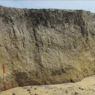
Figure 2 Fluvisol (coastal exposure at Arippu-Sri Lanka)
 contains shell middens and potsherds in top horizon.
 Deltaic deposit of Aruvi-aru river?
Photo-Thilanka Siriwardana

higher sedimentary properties. Significantly, the alluvial, windblown, marine and organic sedimentary properties are apparent. Though the session is online and we are in front of our PCs, it could connect us to the landscapes we have experienced. It was not just about Northwest European and Mediterranean geoarchaeology but also the global principles applicable to any context. Though I was concerned about how I will match the European context where almost all of the participants and resource persons are from Europe, while I am from a remote region, it was successfully incorporated me.


I have recorded the pearl shell middens lying on top of a soil formation washed off by erosion during my fieldworks, another pearl shell midden site lying ca. 4 feet below the surface and continuously covering by dune formation, processes of beach ridge formation and covering the old sites. There are various sediments as alluvial, colluvial, windblown, marine, glacial, volcanic, organic and caves. 

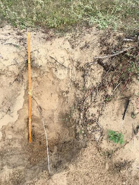
Figure 3 – Arenosol covering Dutch settlement
phase  (Talai-Mannar, Sri Lanka). The dark
brown coloration shows the settlement
phase Photo-Thilanka Siriwardana

While the glacial and volcanic sediments are not available in the Sri Lankan context, other sedimentary systems are apparent. The discussed case studies showed the impact of deforestation to form parabolic dunes in the Netherlands and landscape changes throughout the Holocene in the Netherlands. Similarly, the increasing threat of coastal erosion at Silavathurai-Arippu was identified through satellite images, which could impact the recent marine sand digging off the Negombo coast, Colombo Port City and extensions of Colombo Harbour. Studying the landscape change in the study area is another step to be taken. 

Following the workshop, I have started to gather the GIS data sets of my study area relevant to its geology and geomorphological changes. I am not sure about the applicability of some tools, such as chemical analysis, in my study, but being open to many proxies will provide a better insight into the study area. Knowing how, when, and where to use the geoarchaeology toolbox at the first level of my PhD research is one of the best things.


Further readings

Food and Agriculture Organization of the United Nations, 2014, World reference base for soil resources: International soil classification system for naming soils and creating legends for soil maps, Rome

Sorcha Diskin, Vanessa Mary An Heyvaert,  Kosmas Pavlopoulos, Brigitta Schutt, 2013, Geoarchaeology: A toolbox of approaches applied in a multidisciplinary research discipline, Quaternary International 308-309 (2013) 1–3Figure 3 Arenosol covering Dutch settlement phase

Perera, Nimal, Nikos Kourampas, Ian A. Simpson, Siran U. Deraniyagala, David Bulbeck, Johan Kamminga, Jude Perera, Dorian Q. Fuller, Katherine Szabó, Nuno V. Oliveira, 2011, People of the ancient rainforest: Late Pleistocene foragers at the Batadomba-lena rockshelter, Sri Lanka, Journal of Human Evolution 61: 254-269